Is it welcome to the city of Sandy?


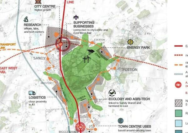
It could include a string of new settlements, a reinstated rail line from Cambridge to Bedford, and a passenger interchange with the East Coast Mainline.
The report, by the National Infrastructure Commission, uses the towns as a case study for the ‘String City’ and stresses the location is “speculative, based only on an initial appraisal of its fit with the characteristics of this typology”.
Advertisement
Hide AdAdvertisement
Hide AdIt states: “The A1 runs to the west of these towns, and there are proposals to upgrade the A1 on a new alignment away from the existing sub-standard road.
“The strategy connects the existing towns with a high quality and efficient to run public transport loop, also linking to the new interchange station and the existing Biggleswade station.
“This loop becomes the armature for a string of new neighbourhoods linking to existing centres and new facilities and workspaces around the ring.
“However, each would also be just a short walk away from the preserved ‘green heart’ of Sandy Warren and Biggleswade Common.”
Advertisement
Hide AdAdvertisement
Hide AdThe Cambridge, Milton Keynes and Oxford corridor plans to link the cities and stimulate economic growth with plans for more than one million new houses by 2050.
Central Bedfordshire Council has signed up to the project and cites the scheme in its pre-submission Local Plan as a means to open up further opportunities for economic growth. Its plan calls for more than 20,000 new homes and 24,000 new jobs between now and 2035.
The NIC report states Sandy Warren, the headquarters of the RSPB and described as “an outstannding environmental asset”, would be at the heart of the new ring city.
“The different settlements within the area would each need a distinctive and complementary economic role. They also need to be very well interconnected by public transport if they are to function as a ring city rather than as an unrelated cluster of expanded towns and villages,” says the report.
Advertisement
Hide AdAdvertisement
Hide AdIt talks about Biggleswade becoming one of only six food enterpise zones in the country and Sandy, logically because of of its rail/road intersection between east west and north south road and road routes “should develop higher order functions to serve the new city’s population as well as a wider catchement.”
The report also discusses a possible busway or tram-train route from Milton Kenyes, through Marston Vale, Cranfield, Bedford and on to Sandy.
There are three potential routes currently under discussion for the Oxford to Cambridgeshire Expressway, which could include an upgrade of the A421.
The report concludes: “Taken together, the case studies and spatial framework demonstrate how the delivery of East West Rail and the Oxford to Cambridge Expressway, if routed and specified correctly, could enable substantial opportunites for the growth of new settlements between Bicester and Bletchely, in Marston Vale, South of Bedford (though, not precluding development in central Bedford), at Sandy and between Sandy and Cambridge.”
The full report can be seen at https://www.nic.org.uk/wp-content/uploads/5thStudio-FinalReport.pdf