Storm Babet latest: Met Office issues red weather warning, flooding in Ireland, UK braces for heavy wind & rain
and live on Freeview channel 276
The UK is bracing itself for heavy wind and rain as Storm Babet sweeps in from across the Atlantic. The Met Office has issued a rare red weather alert for parts of the country, warning of a “risk to life”.
Storm Babet, a complex area of low pressure which developed to the west of the Iberian Peninsula, was named by the Met Office on Monday morning. The second named storm of the season will last until Saturday, the forecaster said, and is expected to cause flooding, power cuts and travel disruption.
National World will be updating this live blog with the latest news as the extreme weather conditions continue to batter the nation.
Storm Babet latest as extreme weather conditions continue to batter the UK
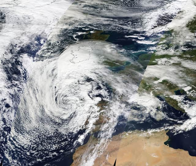
Satellite image shows Storm Babet heading for UK
A satellite image released yesterday shows the progress of Storm Babet as the UK braced for its arrival. The view from space showed the storm on Tuesday (17 October) as it made its way over northern France and towards the UK.
The incredible God's eye view was made possible by NASA's Earth Observing System Data and Information System (EOSDIS). The satellite imagery is available within three hours of observation - essentially showing the entire Earth as it looks "right now".

Met Office latest forecast
The Met Office has released a weather report showing Storm Babet arriving in the south bringing with it heavy downpours. The forecast, presented by Aidan McGivern, confirm conditions are currently drier in the north.
Met Office weather warnings issued across UK
A rare red weather warning stating there is a “risk to life” has been issued for parts of Scotland as Storm Babet is expected to batter the UK on Thursday. The UK is bracing for heavy wind and rain from the storm, which is currently hitting Ireland after sweeping in from the Atlantic.
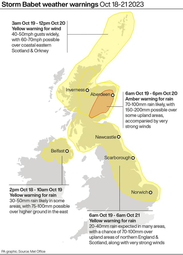
The red warning states there is “danger to life from fast flowing or deep floodwater” in Aberdeenshire and Angus, with extensive flooding and road closures also expected. This is the first red warning for rain issued in the UK since Storm Dennis in February 2020.
Yellow severe weather warnings have been issued across the week from Thursday until Saturday for a vast swathe of the UK, covering already-saturated parts of Scotland, Northern Ireland, and northern and eastern England.
Met Office chief meteorologist, Jason Kelly, said: “Confidence has increased in the chances of considerable impacts from rainfall in parts of the east of Scotland from Storm Babet, which has resulted in the escalation to the red warning. One hundred to 150mm of rain is expected to fall quite widely within the warning period, with some locations likely to see 200-250mm, which is expected to cause considerable impacts, with flooding likely.
“Storm Babet will track gradually northwards in the coming days, and although the most significant impacts are expected within the red and amber warning areas, there will still be wider impacts for much of the UK from this wind and rain.”
Storm Babet weather warnings
The Met Office has issued weather warnings across the UK from today (October 18) until Saturday (October 21).
Do not travel warning: People urged to stay off roads in worst affected areas
David Morgan, flood duty manager for the Scottish Environment Protection Agency (Sepa), has urged people in affected areas to check for flood updates in the coming days. He said: “Storm Babet will bring heavy rain and high winds across Scotland from Wednesday evening, starting in the south-west before moving across to the north-east through Thursday and into the weekend.”
He continued: “Impacts from surface water and rivers are likely, and with catchments saturated from recent heavy rain and flooding, we’re urging people to be prepared for potential flooding. There is also concern that surface-water flooding may be exacerbated by debris blocking drainage, culverts, etc. as a result of the high winds.”
Transport Scotland has advised the public to avoid travel in red warning areas and to expect a high risk of disruption in the amber areas. Operator manager Stein Connelly said: “People need to plan ahead and be prepared. Avoid travel unless essential.
“If you do need to travel, check before you travel as your journey is likely to be affected by these latest severe weather warnings. For those in Angus and South Aberdeenshire, the advice is clear – do not travel during the period the red warning is in effect. The rain is expected to present some really challenging conditions.
“The Multi Agency Response team will be in operation to monitor conditions and co-ordinate our response. However, the public can play a key role by planning ahead. Latest Police Scotland advice is to expect a high risk of disruption across central and the north east of Scotland.
Police are also asking people not to travel across the areas of Angus and South Aberdeenshire. A spokesperson said: “It’s a rapidly moving situation, so please check the Traffic Scotland and Police Scotland social media updates and local radio bulletins for the very latest updates.”
Chief Superintendent Hilary Sloan, head of road policing for Police Scotland, added: “Our advice is to avoid any form of travel during the period of the red weather warning. Driving conditions are expected to be extremely dangerous with disruption and significant delays.
“Amber warnings still remain in place for rain and wind so high-sided vehicles in those areas should consider how essential their journey is. Don’t ignore road closure signs – they are for your safety.”
First Minister Humza Yousaf also warned against all but essential travel in the parts of Scotland affected by the red warning.
He posted on Twitter: “Please be aware of the challenging weather we are due to experience across Scotland, most severe from Thursday 18:00 – Friday 12:00.
“Weather warning across Angus & the North East has been upgraded to red. Travel should be avoided unless absolutely essential.”
Scotland braced for yet more rain
Scotland is braced for even more extreme weather conditions as this image of sand bags piled against a wall in the main street in Aberfoyle in Perthshire demostrates. The village was hit with flooding a couple of weeks ago with Storm Babet expected to bring high winds and heavy rain to the area once again.
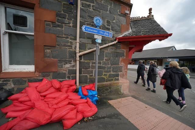
Extensive flooding is forecast in already-saturated parts of Scotland. The Met Office has upgraded a weather warning for rain in eastern Scotland to amber, as some areas could see more than a month's worth of rain in a few days.
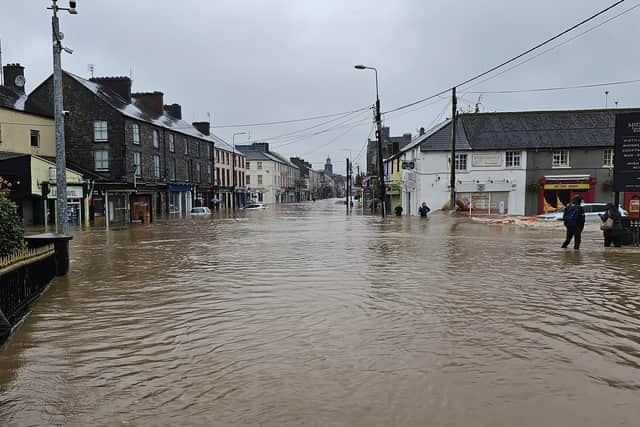
Homes and roads flooded as Storm Babet hits Ireland
Flooding has caused damage and disruption in parts of Ireland as Storm Babet swept in. A number of roads and properties were swamped, with Cork city and the surrounding county among the places worst hit. The town of Midleton in Co Cork was impassable to traffic on Wednesday afternoon (October 18) due flooded roads.
Five counties on the south and south east coasts of Ireland have been subject to orange weather warnings for rain. The alerts issued by forecaster Met Eireann for counties Cork and Kerry ended at 1pm and for Waterford at 4pm. Warnings remain in place for Wexford and Wicklow until 8pm as the storm tracks northward.
Euan Whelton, 21 from the village of Glandore, in Co Cork said he has not seen flooding “this bad” in 10 years saying the harbour village was “closed down” in 2013 due to heavy flooding. He said: “There were a few houses down there that were flooded, there was probably a foot or two of water inside the houses.
“There was a riverbank burst and it flooded on the houses down there, there was a high tide as well so it was hard to get the water out. The fire brigade was there for probably five or six hours pumping it out but it’s still all underwater at the moment (Wednesday afternoon).”
Mr Whelton added that in one of his cousin’s houses, the water was “coming in the back door and going straight out the front door”.
Co Cork mayor Frank O’Flynn said one month’s worth of rain had fallen in 24 hours. “This is on top of already saturated lands and high river levels,” he said. “It is evidence, if any were needed, of our changing climate and the issues that it presents.”
He added: “The results of this weather event will be long felt as we move toward a clean up phase but can I please reiterate the importance of staying safe and together we will come through this weather event.”
A yellow rain warning covering the province of Connacht and counties Clare, Limerick, Tipperary and Cork is set to end at 6pm while a similar yellow warning for the province of Leinster and counties Cavan, Donegal, Monaghan and Waterford will remain in place until 8pm.
Met Office red weather warning explained
The Met Office went live on Facebook to talk about Storm Babet, in particular the red weather warning issued for parts of Scotland.
Morning update - Babet sweeps Ireland and heads for England today
The UK is bracing for impact from Storm Babet, with a rare red weather warning in place as Ireland endures flooding in the wake of the storm.
Storm Babet will bring 70mph gusts and over one month’s worth of rain in the worst-affected regions of the UK on Thursday.
A red Met Office warning says from 6pm there is “danger to life from fast-flowing or deep floodwater” in Aberdeenshire and Angus in eastern Scotland, with extensive road closures expected.
There may be power outages and some areas could be cut off for days, with people urged to check for flood updates, avoid travel and expect school closures.
Angus Council said schools will close at lunchtime on Thursday and remain shut on Friday to “ensure the safety of children, young people, parents, and school staff”.
Mass train cancellations have been imposed by ScotRail, expected to last from Thursday until Saturday.
The Scottish Environment Protection Agency has three flood warnings in place as of 6am, along with 14 flood alerts.
It is the first red warning for rain issued in the UK since Storm Dennis in February 2020.
An amber wind warning has also been issued for parts of eastern Scotland.
Met Office forecaster Greg Dewhurst said: “We’re going to see prolonged heavy rain, where we could see 200 to 250 millimetres of rain falling within a day which is well over a month’s worth of rainfall for eastern parts of Scotland.
“We’re likely to see flooding, power disruption, travel disruption, there is a risk to life as well.
“There’s also an amber wind warning out for eastern parts of Scotland, where we could see gusts of 60 to 70 miles an hour, just adding to the extremely dangerous weather coming for parts of Scotland.”
Storm Babet hit Ireland on Wednesday after sweeping in from the Atlantic, bringing with it heavy rainfall and causing extensive flooding in parts of the country.
Members of the Irish Defence Forces were deployed in the town of Midleton, Co Cork in the south of Ireland, where more than 100 properties were flooded.
Cork County Council said more than a month’s worth of rain had fallen in the space of 24 hours, leading to unprecedented flooding, saturated land and high river levels across the county.
Large swathes of already-saturated Scotland, Northern Ireland, and northern and eastern England will also see strong winds and heavy rain on Thursday, with yellow severe weather warnings issued through to Saturday.
Storm Babet, a complex area of low pressure which developed to the west of the Iberian peninsula, was named by the Met Office on Monday morning.
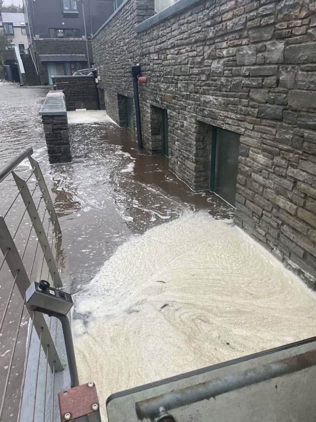
Severe flooding in Ireland
A photo by Damien Rytel showing flooding in Midleton, Co Cork caused by Storm Babet. The army and civil defence units supported evacuation measures in Midleton where more than 100 properties were flooded